UPCOMING EXPEDITIONS
Expedition Kilimanjaro
TANZANIA, AUGUST 21-31, 2026
Introduction: In partnership with IK Expeditions, BraveHearts Expeditions brings to you a Ghana Expedition to Mt Kilimanjaro via the Machame Route. The Machame Route up Mt. Kilimanjaro is nicknamed the “Whiskey” route because it is considered somewhat challenging and more expensive than the Marangu route. However, when comparing routes to climb Kilimanjaro, this is one of the best options for both acclimatisation and affordability. It is better suited for more adventurous trekkers and those with some hiking or backpacking experience. The Machame route is a scenic, diverse path that approaches the summit from the southwest and descends via the Mweka route. It offers expansive views of the Shira Plateau, an optional scramble up Lava Tower, a climb up the Great Barranco wall, and a traverse beneath Kilimanjaro’s southern ice field.
August 21: Flight Departs Accra to Kilimanjaro
August 22: Pre-Trek Briefing: Adventurers are transferred from Kilimanjaro Airport to hotels in Moshi, where equipment is reviewed to determine whether any additional items need to be rented.
August 23: Hotel to Machame Camp – The drive from Moshi to Machame Gate takes approximately 45 minutes. The journey passes through the village of Machame, situated on the lower slopes of Mt. Kilimanjaro. We depart the park gate and walk through the rainforest on a winding trail up a ridge. At lower elevations, the trail can be muddy and slippery. Gaiters and trekking poles are a good idea here. We continue for a short distance until we reach the Machame Camp.
Elevation: 1830m/6000ft to 3050m/9950ft
Distance: 11km/7mi
Hiking Time: 5-6 hours
Habitat: Montane Forest
Meals: Lunch and Dinner
August 24: Machame Camp to Shira Camp: After breakfast, we leave the rainforest glades and continue on an ascending path, crossing the valley along a steep, rocky ridge. The route now turns west onto a river gorge until we arrive at the Shira campsite.
Elevation: 3050m/9950ft to 3850m/12,600ft
Distance: 5km/3mi
Walking Time: 4-5 hours
Habitat: Moorland
Meals: Breakfast, Lunch and Dinner
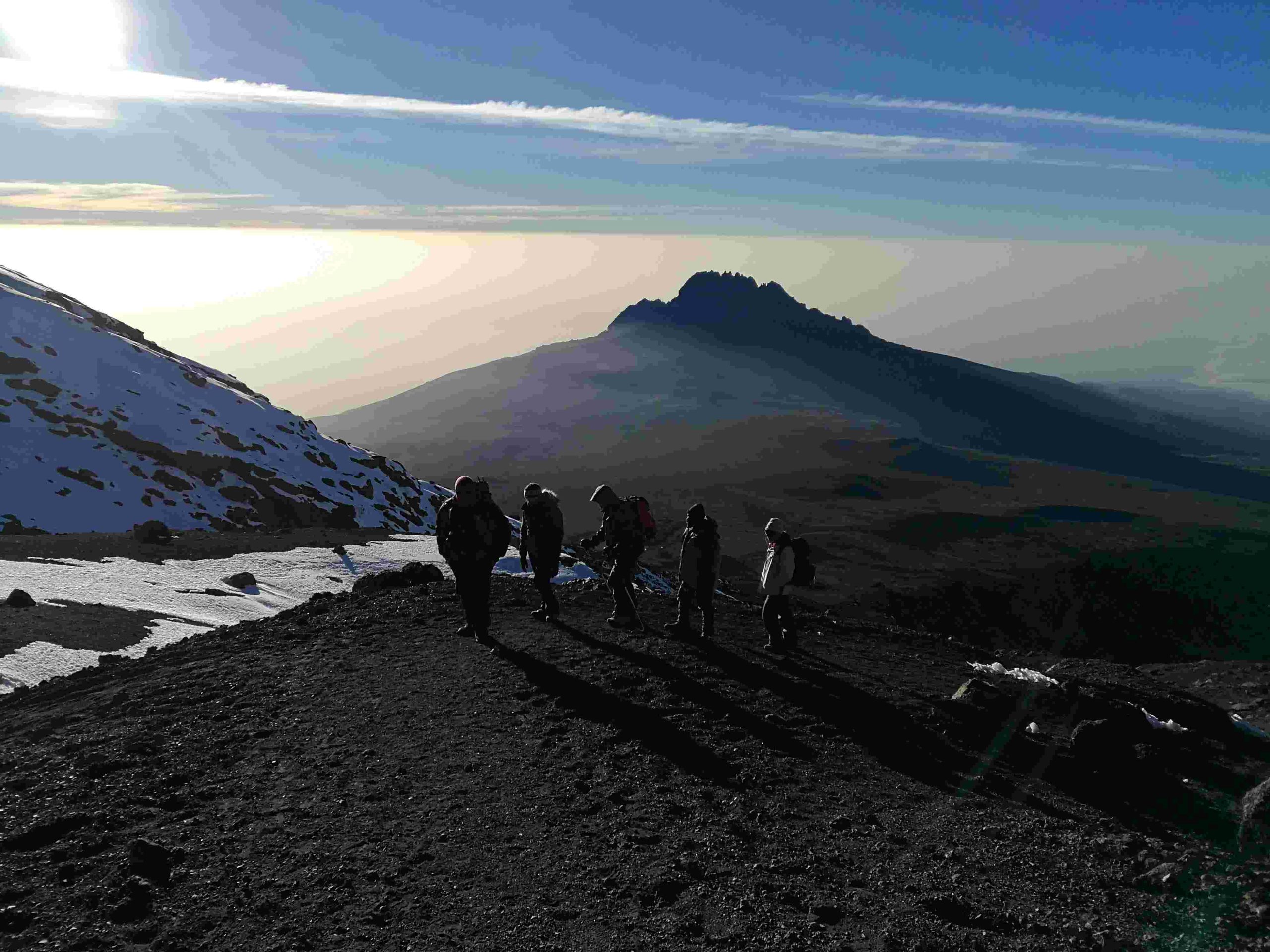
August 25: Shira Camp to Lava Tower to Barranco Camp: From the Shira Plateau, we continue East up a ridge, passing the junction leading to the summit of Kibo. As we continue, our direction changes Southeast towards the Lava Tower, also known as the “Shark’s Tooth” (elevation 4650m/15,250ft). Shortly after the tower, we come to the second junction, which goes to the Arrow Glacier. We now continue down to the Barranco Camp. Although we end the day around the same elevation as when we began, this day is significant for acclimatisation and will help our bodies prepare for summit night.
Elevation: 3850m/12,600ft to 4000m/13,000ft
Distance: 10km/6mi
Walking Time: 5-6 hours
Habitat: Semi-desert
Meals: Breakfast, Lunch and Dinner
August 26: Barranco Camp to Barafu Camp: After breakfast, we leave Barranco and continue on a steep ridge up the Barranco Wall (elev 4250m/13,900ft), through the Karanga Valley (elev 4050m/13,250ft) to the junction which connects with the Mweka Trail. We continue up to the Barafu Camp. We would have completed the South Circuit, which offers views of the summit from many different angles. Here, we camp with views of the summit in the distance.
Elevation: 4000m/13,000ft to 4700m/15,350ft
Distance: 9km/6mi
Hiking Time: 6-8 hours
Habitat: Alpine Desert
Meals: Breakfast, Lunch and Dinner
August 27: Barafu Camp to Summit to Mweka Camp: Very early in the morning (midnight to 2 am), we continue on our way to the summit between the Rebmann and Ratzel glaciers. We head in a northwesterly direction and ascend through heavy scree towards Stella Point on the crater rim. This is the most mentally and physically challenging portion of the trek. At Stella Point, we will stop for a short rest and will be rewarded with the most magnificent sunrise we are ever likely to see. Faster hikers may be able to view the sunrise from the summit.
From Stella Point, we may encounter snow all the way on our 1-hour ascent to the summit. Once at Uhuru Peak, we would have reached the highest point on Mount Kilimanjaro and the continent of Africa! From the summit, we begin our descent by continuing straight down to the Mweka Camp, stopping at Barafu for lunch. Gaiters and trekking poles are necessary for navigating the loose gravel on the way down. We arrive at Mweka Camp and enjoy our last evening on the mountain.
Elevation: 4700m/15,350ft to 5895m/19,340ft
Down to 3090m/10,150ft
Distance: 5km/3mi up / 13km/8mi down
Hiking Time: 5-7 hours up / 5-6 hours down
Habitat: Stone scree and ice-capped summit
Meals: Breakfast, Lunch and Dinner
August 28: Mweka Camp to Mweka Gate to Hotel: After breakfast, we continue the descent down to the Mweka Park Gate to receive our summit certificates. At lower elevations, it can be wet and muddy. Shorts and t-shirts will probably be good to wear at this stage (keep rain gear and warmer clothing handy). Vehicles will be waiting at Mweka Gate to transport adventurers back to their hotels in Moshi (approximately 60 minutes).
Elevation: 3090m/10,150ft to 1680m/5500ft
Distance: 10km/6mi
Hiking Time: 3-4 hours
Habitat: Forest
Meals: Breakfast
August 29: Layover Day. A day of rest and optional city sightseeing
August 30: Return Flights to Accra
Price Inclusions:
Professional, experienced mountain guides
Quality, waterproof, four-season mountain sleeping tents
Clean, purified drinking water
Sleeping Mattresses
Guides, Porters, Cooks’ salaries and park fees
Kilimanjaro summit certificates
Quality Mess tents with table and chairs
Emergency Oxygen & Comprehensive First Aid Kit
Conservation fees (part of park fees)
All meals while on the Mountain
Rescue fees (part of park fees)
All transfers to the mountain and back to Moshi hotels
Large portions of fresh, healthy, nutritious food
Camping or Hut fees (part of park fees)
Porter tipping fees
Airport transfers
Price Exclusions:
Travel insurance
Liquors, beers and bottled beverages
Non-expedition tips and gratuities
Personal trekking equipment such as sleeping bags, hiking boots, clothes, etc (available for renting)
International and domestic flights
Meals not listed in the itinerary.
Personal Expenses (e.g. laundry, telephone, beverages, etc.)
Tanzania Visa (where applicable)
The expedition costs $2,500. We estimate that renting the needed gear will cost an additional $350. Please budget an extra $150 for layover-day expenses and about $1,500 for return flights.
Call 054-842-4903 to reserve your spot.
The Twin Islands Expedition
LAKE VOLTA, JANUARY 11-12, 2027
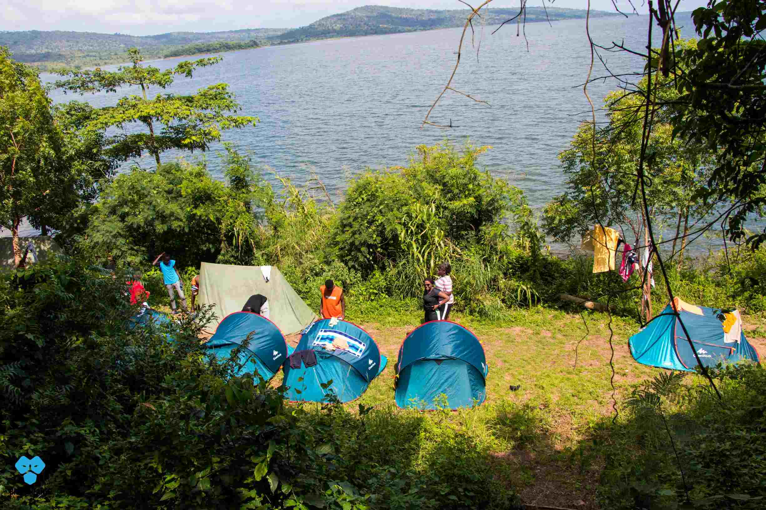
Located in the middle of the two mountain ranges that form the Akwamu Gorge, the Twin Islands are an adventurer’s paradise. The expedition to the Twins will begin on Day 1 with a drive from the Accra Mall at 6 a.m. through the Trident for supplies, and a 15km hike from Mpakadan through roughly undulating hills to Survival beach. A 3km Kayaking foray is our way of accessing Survival Island, the bigger of the Twins. We’ll perform the mandatory capsize drills on the kayaking journey to Survival Island just to be sure kayakers know how to stay safe when the unexpected happens, and Lake Volta has some of the most unpredictable weather we know. The night on Survival Island will be calm and peaceful, broken only by the constant wash of the waves and the cries of dozens of birds.
Day 2 on the Twin Islands will start with a 7km kayaking expedition to a cove near the foot of the Anum forest from where we will assault the Anum plateau on the exit adventure. The expedition costs 3,150-GHC and covers transport, food, water, group kit and equipment, and photography. Call 020-454-8040 or 054-842-4903 to reserve your spot.
Wilderness Survival Expedition
KWAHU-OWOROBONG, FEBRUARY 15-16, 2027
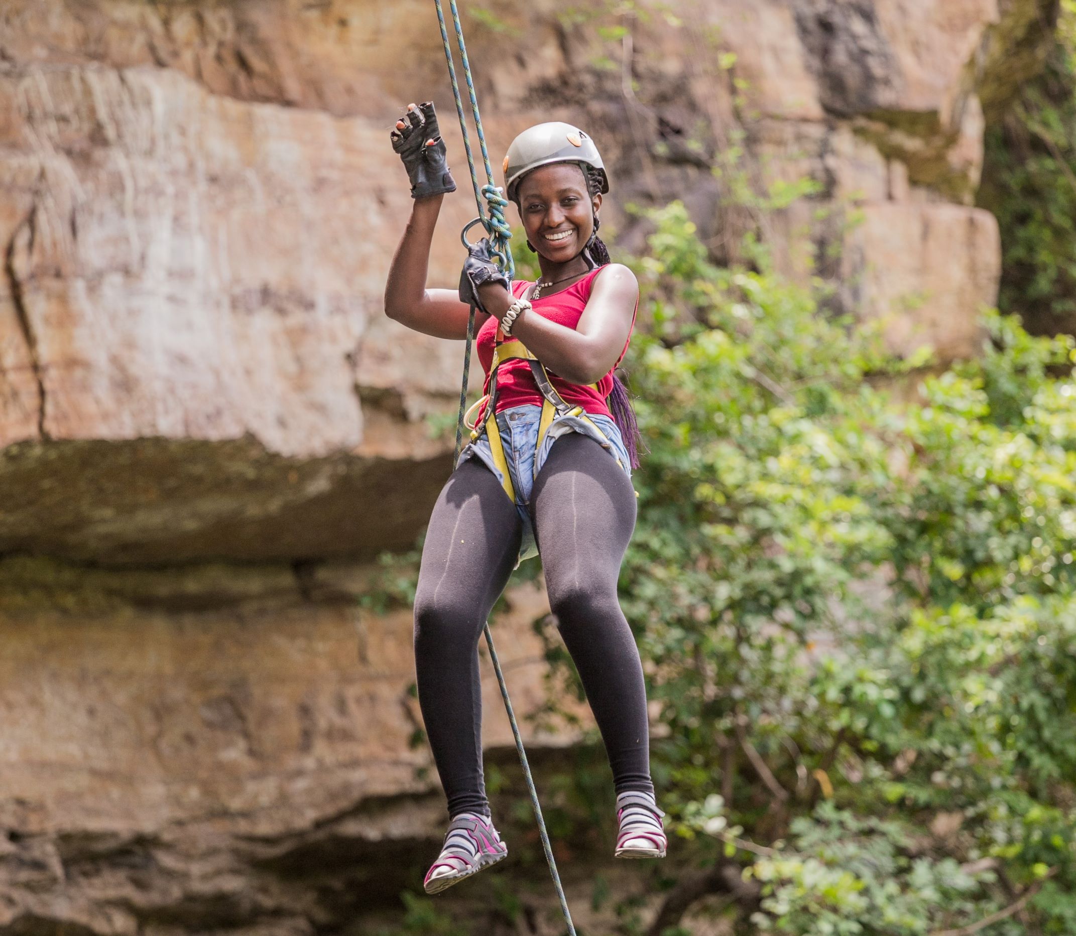
In the rainy season no one can abseil the sheer rockface of Oworobon when the whole river is pouring over the cliff edge. In the harmattan however, the 50-metre empty bedrock is the adrenaline seeker’s heart stopping fantasy. This is why we will be exploring the Kwahu wilderness in February. We’ll leave the Accra Mall at 6 a.m., drive to Kwahu and trek across the vast expanse of the Kwahu Highlands from Kwahu Bepong to the top of the Oworobon cliff where the dizzying abseil adventure will begin.
On Day 2, we’ll complete the loop across the ridges and through Fulani cattle-infested wilderness towards Adawso for the return trip to Accra.
Transportation, food, tents, water, guiding services and photography are inclusive of the 3,150-Ghana Cedis package. Call 020-454-8040 to book your spot.
Expedition Beyond Afadjato
TOGOLESE HIGHLANDS, MARCH 8-9, 2027
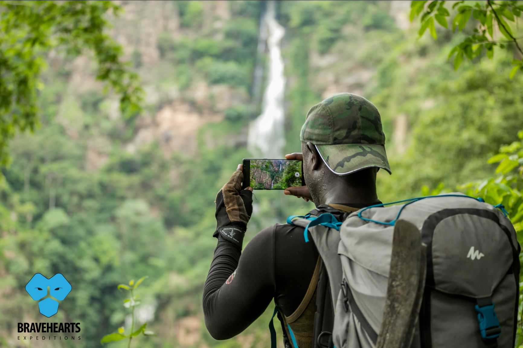
1,050-metres. That’s the highest we will go after we have climbed Afadjato and crossed the invisible border between Ghana’s eastern mountain ranges and the Togolese Republic. Nerves of steel, a high tolerance for uncertainty and adversity, and enduring stamina are required for this overnight assault of Afadjato, Ghana’s highest free-standing mountain at 640m. A Togolese highlands invasion continues from the top of Afadjato across the invisible boundary into the western Plateau region of the Togolese Republic. By the time we arrive at Wli Todzi on the Ghanaian side of the highlands, we would have completed a tough 5-hour or more journey across the highest mountains in Ghana’s highland border with Togo on Day 1.
Another 4 hours will mark the descent from Wli Todzi to the upper and lower trails of the Wli waterfalls area the next day. A rain-gouged chimney is the butt-dragging trail down the steep range into the refreshing waters of the lower Wli falls. Splashing around in the falls and touching the wall behind the curtain is the phenomenon that makes the grueling adventure worth it, at 3,150 Ghana Cedis.
This adventure is built for endurance and requires a basic level of physical fitness. Those mountains don’t play. Call 020-454-8040 or 054-842-4903 to reserve your spot.
We’ll leave the Accra mall at 6 a.m. on March 8 and drive to the Trident for supplies before driving up the Eastern corridor highway to Liate Wote, the reception at the foot of Afadjato.